
Features ピンポイント雷雨 – 高精度な落雷情報をリアルタイムで取得。
■ World-class lightning observation network "JLDN"The lightning strike information obtained by "Pinpoint Thunderstorm" is acquired by JLDN (Japanese Lightning Detection Network).
JLDN is a national lightning observation network operated by Franklin Japan.
It is composed of 31 sensors from Hokkaido to Okinawa, and is an observation network that seamlessly covers the whole of Japan.
JLDNs lightning positioning accuracy has an average position error of 300 m or less, which is almost the same accuracy as the global large-scale lightning observation networks such as NALDN (North America) and EUCLID (Europe).■ How to use[Basic operation]Turn on the GPS function and start the app.
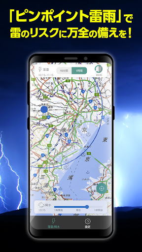
Information on lightning strikes within a radius of 50 km from your current location is displayed on the map.
You can zoom in and out on the map by pinching in and out.[Lightning strike information]Display JLDN data.
The display data is limited to lightning strikes and is the position data up to the second decimal place of longitude and latitude.
By clicking the button labeled "10 minutes" or "1 hour" on the "Lightning strike / precipitation" screen, you can switch between displaying only the latest lightning strike and displaying the 1-hour history.[Precipitation information]Displays "past / present / forecast" information of precipitation.
By operating the slider at the bottom of the screen, you can switch the display between the current time and the hour before and after.
The left side of the bar is the "past" information and the right side is the "forecast" information.[Reduction of update time]You can shorten the lightning strike information update interval by tapping the refresh button and watching a short video ad.10-minute interval → 1-minute interval (valid for 30 minutes)[Map switching]The map that displays lightning strike / precipitation information can be selected from the following three types.
Feel free to use it according to your needs.・ Geospatial Information Authority of Japan light-colored map・ Geospatial Information Authority of Japan standard map・ Open Street Map
Secure & Private
Your data is protected with industry-leading security protocols.
24/7 Support
Our dedicated support team is always ready to help you.
Personalization
Customize the app to match your preferences and workflow.
See the ピンポイント雷雨 – 高精度な落雷情報をリアルタイムで取得。 in Action


Get the App Today
Available for Android 8.0 and above